Geolocate

Windsor topographic map

Click on the map to display elevation.

About this map

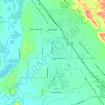
Name: Windsor topographic map, elevation, terrain.

Location: Windsor, Sonoma County, California, 95492, United States (38.49230 -122.86114 38.56740 -122.77247)

Average elevation: 39 m

Minimum elevation: 8 m

Maximum elevation: 161 m

Other topographic maps

Click on a map to view its topography, its elevation and its terrain.

Healdsburg

United States > California > Sonoma County

Average elevation: 45 m

Cazadero

United States > California > Sonoma County

Average elevation: 173 m

Petaluma

United States > California > Sonoma County > Petaluma

Average elevation: 117 m

Petaluma

United States > California > Sonoma County

Average elevation: 131 m

Gear up for your next adventure:

🧢Hiking Hat - Sun-protective and breathable hats for long treks
🥾Mountain Hiking Boots - High-traction boots for rocky terrain
🧤Insulated Winter Gloves - Heavy-duty protection for sub-zero Canadian adventures
🥾Hiking Shoes - Durable and comfortable shoes for trail hiking
🦶Anti-Blister Balm - Prevents friction and hotspots during long ascents

As an Amazon Associate, this site earns from qualifying purchases at no extra cost to you.