
Asturias topographic map
Interactive map
Click on the map to display elevation.
About this map
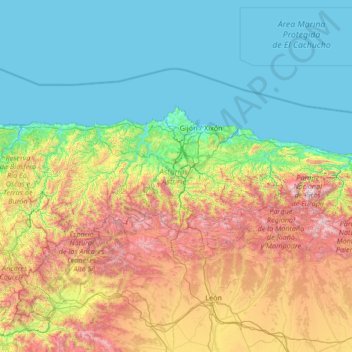
Name: Asturias topographic map, elevation, terrain.
Location: Asturias, Spain (42.88254 -7.18317 43.66653 -4.51059)
Average elevation: 569 m
Minimum elevation: -2 m
Maximum elevation: 2,593 m
Other topographic maps
Click on a map to view its topography, its elevation and its terrain.
San Martín de Oscos
San Martín de Oscos, Asturias, 33777, Spain
Average elevation: 680 m
La Pimpana
La Pimpana, Quirós, Asturias, 33628, Spain
Average elevation: 1,683 m
Ribadesella
Spain > Asturias > Ribadesella
Ribadesella, Asturias, 33560, Spain
Average elevation: 153 m
Cantabrian Mountains
Cantabrian Mountains, Cabrales, Asturias, Spain
Average elevation: 2,201 m