
Mokokchung topographic map
Interactive map
Click on the map to display elevation.
About this map
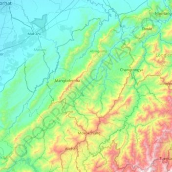
Name: Mokokchung topographic map, elevation, terrain.
Location: Mokokchung, Nagaland, India (26.19380 94.28956 26.76546 94.75764)
Average elevation: 561 m
Minimum elevation: 89 m
Maximum elevation: 2,272 m
Other topographic maps
Click on a map to view its topography, its elevation and its terrain.
Chessore Village
Chessore Village, Chessore, Tuensang, Nagaland, India
Average elevation: 1,325 m
Mokokchung
India > Nagaland > ONGPANGKONG (N)
Mokokchung, ONGPANGKONG (N), Mokokchung District, Nagaland, 798601, India
Average elevation: 1,027 m
Kohima
India > Nagaland > Kohima Sadar
Kohima, Kohima Sadar, Kohima District, Nagaland, 797001, India
Average elevation: 1,425 m