
Thank you for supporting this site ❤️
Make a donation
Make a donation
Gear up for your next adventure:
As an Amazon Associate, this site earns from qualifying purchases at no extra cost to you.
Berevoești topographic map
Click on the map to display elevation.
Thank you for supporting this site ❤️
Make a donation
Make a donation
Gear up for your next adventure:
As an Amazon Associate, this site earns from qualifying purchases at no extra cost to you.
About this map
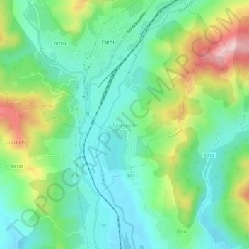
Name: Berevoești topographic map, elevation, terrain.
Location: Berevoești, Fieni, Dâmbovița, 135101, Romania (45.09734 25.40337 45.13734 25.44337)
Average elevation: 489 m
Minimum elevation: 411 m
Maximum elevation: 657 m
Thank you for supporting this site ❤️
Make a donation
Make a donation
Gear up for your next adventure:
As an Amazon Associate, this site earns from qualifying purchases at no extra cost to you.