
Make a donation
Gear up for your next adventure:
As an Amazon Associate, this site earns from qualifying purchases at no extra cost to you.
Talmage topographic map
Click on the map to display elevation.
Make a donation
Gear up for your next adventure:
As an Amazon Associate, this site earns from qualifying purchases at no extra cost to you.
About this map
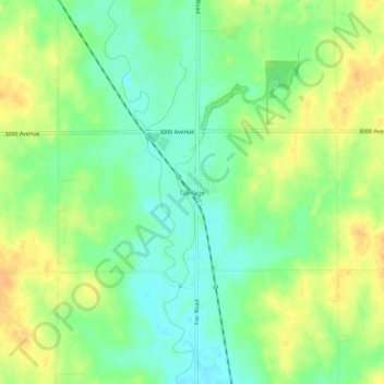
Name: Talmage topographic map, elevation, terrain.
Location: Talmage, Dickinson County, Kansas, 67482, United States (39.00500 -97.28058 39.04500 -97.24058)
Average elevation: 380 m
Minimum elevation: 365 m
Maximum elevation: 396 m
Make a donation
Gear up for your next adventure:
As an Amazon Associate, this site earns from qualifying purchases at no extra cost to you.
Other topographic maps
Click on a map to view its topography, its elevation and its terrain.
Abilene
United States > Kansas > Dickinson County
Abilene is at 38°55′11″N 97°13′2″W / 38.91972°N 97.21722°W / 38.91972; -97.21722 (38.919721, −97.217329) at an elevation of 1,155 feet (352 m). The city is on the north side of the Smoky Hill River in the Flint Hills region of the Great Plains. Mud Creek, a tributary of the Smoky Hill,…
Average elevation: 357 m
Make a donation
Gear up for your next adventure:
As an Amazon Associate, this site earns from qualifying purchases at no extra cost to you.