Geolocate

Chamana topographic map

Click on the map to display elevation.

About this map

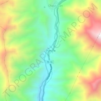
Name: Chamana topographic map, elevation, terrain.

Location: Chamana, Llacllín, Recuay, Áncash, Perú (-10.22450 -77.57732 -10.18450 -77.53732)

Average elevation: 1,607 m

Minimum elevation: 1,137 m

Maximum elevation: 2,330 m

Gear up for your next adventure:

🧢Outdoor Visor - Breathable visor for sunny hikes
🐕Hiking Dog Pack - Let your canine companion carry their own water and food
🧢Outdoor Cap - Protective cap for sun and rain during hikes
🧦Thermal Socks - Warm socks for winter hiking or camping
👟Leg Gaiters - Keep debris, mud, and snow out of your boots

As an Amazon Associate, this site earns from qualifying purchases at no extra cost to you.