
Make a donation
Gear up for your next adventure:
As an Amazon Associate, this site earns from qualifying purchases at no extra cost to you.
Ljubljana topographic map
Click on the map to display elevation.
Make a donation
Gear up for your next adventure:
As an Amazon Associate, this site earns from qualifying purchases at no extra cost to you.
Ljubljana
Ljubljana has an elevation of 295 meters (968 ft) The city centre, located along the Ljubljanica River, has an elevation of 298 meters (978 ft). Ljubljana Castle, which sits atop Castle Hill (Grajski grič) south of the city centre, has an elevation of 366 meters (1,201 ft). The highest point of the city, called Grmada, reaches 676 meters (2,218 ft), 3 meters (9.8 ft) more than the nearby Mount Saint Mary (Šmarna gora) peak, a popular hiking destination. These are located in the northern part of the city.
Make a donation
Gear up for your next adventure:
As an Amazon Associate, this site earns from qualifying purchases at no extra cost to you.
About this map
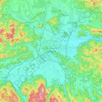
Name: Ljubljana topographic map, elevation, terrain.
Location: Ljubljana, Upravna Enota Ljubljana, 1000, Slovenia (45.89003 14.34693 46.21003 14.66693)
Average elevation: 412 m
Minimum elevation: 254 m
Maximum elevation: 1,094 m
Make a donation
Gear up for your next adventure:
As an Amazon Associate, this site earns from qualifying purchases at no extra cost to you.
Other topographic maps
Click on a map to view its topography, its elevation and its terrain.