
Make a donation
Gear up for your next adventure:
As an Amazon Associate, this site earns from qualifying purchases at no extra cost to you.
Rutland Town topographic map
Click on the map to display elevation.
Make a donation
Gear up for your next adventure:
As an Amazon Associate, this site earns from qualifying purchases at no extra cost to you.
Rutland Town
The town was originally granted in 1761 by Governor Benning Wentworth as one of the New Hampshire Grants. He named it after John Manners, 3rd Duke of Rutland. It is also recorded that John Murray who was the first named proprietor and from Rutland named it. It was one of the most successful of those grants because of the excellent farmland and gentle topography.
Make a donation
Gear up for your next adventure:
As an Amazon Associate, this site earns from qualifying purchases at no extra cost to you.
About this map
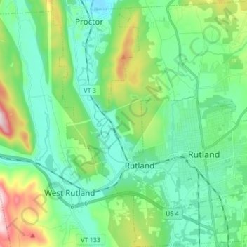
Name: Rutland Town topographic map, elevation, terrain.
Location: Rutland Town, Rutland County, Vermont, United States (43.57174 -73.03284 43.66948 -72.93416)
Average elevation: 229 m
Minimum elevation: 107 m
Maximum elevation: 605 m
Make a donation
Gear up for your next adventure:
As an Amazon Associate, this site earns from qualifying purchases at no extra cost to you.
Other topographic maps
Click on a map to view its topography, its elevation and its terrain.
Make a donation
Gear up for your next adventure:
As an Amazon Associate, this site earns from qualifying purchases at no extra cost to you.
Billings Mobile Manor
United States > Vermont > Rutland County > Rutland City
Average elevation: 211 m
Make a donation
Gear up for your next adventure:
As an Amazon Associate, this site earns from qualifying purchases at no extra cost to you.
Make a donation
Gear up for your next adventure:
As an Amazon Associate, this site earns from qualifying purchases at no extra cost to you.
West Tinmouth
United States > Vermont > Rutland County > Tinmouth > West Tinmouth
Average elevation: 419 m