
Make a donation
Gear up for your next adventure:
As an Amazon Associate, this site earns from qualifying purchases at no extra cost to you.
Mount Angel topographic map
Click on the map to display elevation.
Make a donation
Gear up for your next adventure:
As an Amazon Associate, this site earns from qualifying purchases at no extra cost to you.
Mount Angel
Rev. Fr. Adelhelm Odermatt, O.S.B., came to Oregon in 1881 with a contingent of Benedictine monks from Engelberg, Switzerland, in order to establish a new American daughter house. After visiting several locations, he found Lone Butte to be the ideal location for a new abbey, and shortly afterwards ministered to several local Roman Catholic parishes, about the same time large numbers of immigrants from Bavaria settled in the area. Due to his efforts, the city, post office and the nearby elevation Lone Butte came to be known as Mount Angel (an English translation of Engelberg) in 1883. He also established Mount Angel Abbey, a Benedictine monastery and school, which was moved permanently to Mt. Angel in 1884.
Make a donation
Gear up for your next adventure:
As an Amazon Associate, this site earns from qualifying purchases at no extra cost to you.
About this map
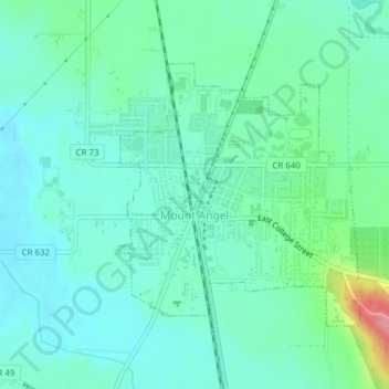
Name: Mount Angel topographic map, elevation, terrain.
Location: Mount Angel, Marion County, Oregon, United States (45.06008 -122.80715 45.07834 -122.78338)
Average elevation: 58 m
Minimum elevation: 36 m
Maximum elevation: 134 m
Make a donation
Gear up for your next adventure:
As an Amazon Associate, this site earns from qualifying purchases at no extra cost to you.