
Ramah topographic map
Click on the map to display elevation.
Ramah
Lying at 6926 feet above sea level, Ramah is considered by some as a high desert, but at higher elevations in includes tall pines, sandstone cliffs, and timber covered mountains. Much of the lower landscape in the surrounding area is covered with lava flows from the chain of volcanos to the south. Intermixed in the scenery are ruins of an ancient people who dotted the land.
About this map
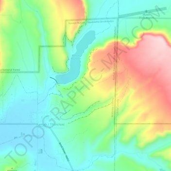
Name: Ramah topographic map, elevation, terrain.
Location: Ramah, McKinley County, New Mexico, United States (35.12004 -108.51534 35.16785 -108.46848)
Average elevation: 2,184 m
Minimum elevation: 2,095 m
Maximum elevation: 2,354 m