Geolocate

Sitges topographic map

Click on the map to display elevation.

About this map

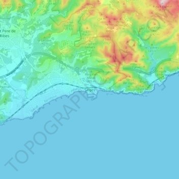
Name: Sitges topographic map, elevation, terrain.

Location: Sitges, Garraf, Barcelona, Cataluña, 08870, España (41.19667 1.78281 41.27667 1.86281)

Average elevation: 62 m

Minimum elevation: 0 m

Maximum elevation: 382 m

Gear up for your next adventure:

💡Compact LED Flashlight - Powerful and portable flashlight for outdoor use
🥾Trail Running Shoes - Lightweight and durable shoes for trail running
🚲Bike Repair Kit - Essential tools for on-trail mechanical issues
🥾Mountaineering Boots - Supportive boots for climbing and high-altitude hiking
🧼Travel Hand Sanitizer - Keep hands clean when water is scarce

As an Amazon Associate, this site earns from qualifying purchases at no extra cost to you.