Geolocate

Thane topographic map

Click on the map to display elevation.

About this map

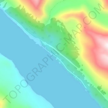
Name: Thane topographic map, elevation, terrain.

Location: Thane, Juneau, Alaska, United States (58.23805 -134.33844 58.27805 -134.29844)

Average elevation: 176 m

Minimum elevation: -12 m

Maximum elevation: 765 m

Gear up for your next adventure:

🥘Camping Cookware Set - Compact nesting pots and pans for trail cooking
🔭Compact Monocular - One-handed bird watching and trail spotting
🧣Evaporative Cooling Towel - Beat the heat during intense summer climbs
🧢Hiking Sun Hat - Wide-brimmed protection for exposed mountain ridges
🥾Trail Hiking Shoes - Durable shoes designed for rugged trails

As an Amazon Associate, this site earns from qualifying purchases at no extra cost to you.