
Sébastopol topographic map
Interactive map
Click on the map to display elevation.
About this map
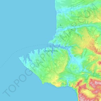
Name: Sébastopol topographic map, elevation, terrain.
Location: Sébastopol, 299911, Ukraine (44.44544 33.36208 44.76544 33.68208)
Average elevation: 73 m
Minimum elevation: -2 m
Maximum elevation: 617 m
La ville est fondée en 1783, après la première annexion de la Crimée par la Russie, et devient une importante base navale et un port de commerce florissant. Ce choix s'explique par sa topographie, selon Jean-François Gamba, qui en fait la description à l'occasion de son second voyage dans la partie méridionale de l'Empire russe dans les années 1820.
Other topographic maps
Click on a map to view its topography, its elevation and its terrain.
Херсонес Таврический
Ukraine > Sébastopol > Sébastopol
Херсонес Таврический, Главная улица Херсонеса, Sébastopol, Гагаринский район, Sébastopol, 99000, Ukraine
Average elevation: 12 m