Geolocate

Corydon topographic map

Click on the map to display elevation.

About this map

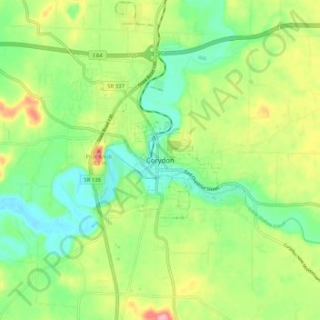
Name: Corydon topographic map, elevation, terrain.

Location: Corydon, Harrison County, Indiana, 471112, United States (38.17293 -86.16539 38.25293 -86.08539)

Average elevation: 202 m

Minimum elevation: 153 m

Maximum elevation: 283 m

Gear up for your next adventure:

🦶Hiking Shoe Insoles - Added support for high arches and long days on feet
🥾Mountain Hiking Shoes - Shoes with superior grip for mountainous terrain
🚲Heavy Duty Bike Lock - Secure your bike at the trailhead or during stops
🧴Bear Spray Holster - Quick-access carry for essential Canadian wilderness safety
🔦UV Flashlight - Detect minerals or specific insects in the dark

As an Amazon Associate, this site earns from qualifying purchases at no extra cost to you.