Geolocate

Millfield topographic map

Click on the map to display elevation.

About this map

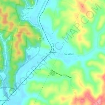
Name: Millfield topographic map, elevation, terrain.

Location: Millfield, Athens County, Ohio, 45761, United States (39.41285 -82.11681 39.45285 -82.07681)

Average elevation: 237 m

Minimum elevation: 196 m

Maximum elevation: 318 m

Gear up for your next adventure:

🕶️Polarized Sunglasses - Reduces glare from snow and water at high elevations
🔋Lithium AA Batteries - Long-lasting power that performs in extreme cold
🧥Insulated Jacket - Keep warm in cold outdoor conditions
Camping Essentials - All-in-one gear for a comfortable camping trip
🧦Outdoor Socks - Durable socks designed for hiking and outdoor sports

As an Amazon Associate, this site earns from qualifying purchases at no extra cost to you.