
Thank you for supporting this site ❤️
Make a donation
Make a donation
Gear up for your next adventure:
As an Amazon Associate, this site earns from qualifying purchases at no extra cost to you.
Söğüt topographic map
Click on the map to display elevation.
Thank you for supporting this site ❤️
Make a donation
Make a donation
Gear up for your next adventure:
As an Amazon Associate, this site earns from qualifying purchases at no extra cost to you.
About this map
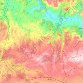
Name: Söğüt topographic map, elevation, terrain.
Location: Söğüt, Bilecik, Marmara Region, Turkey (39.84053 30.04468 40.15782 30.36547)
Average elevation: 726 m
Minimum elevation: 133 m
Maximum elevation: 1,366 m
Thank you for supporting this site ❤️
Make a donation
Make a donation
Gear up for your next adventure:
As an Amazon Associate, this site earns from qualifying purchases at no extra cost to you.