Geolocate

Simeria topographic map

Click on the map to display elevation.

About this map

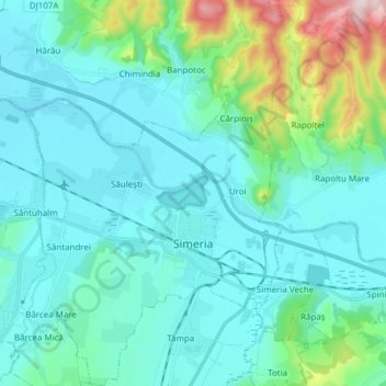
Name: Simeria topographic map, elevation, terrain.

Location: Simeria, Hunedoara, Romania (45.80821 22.94823 45.91448 23.07147)

Average elevation: 259 m

Minimum elevation: 179 m

Maximum elevation: 689 m

Gear up for your next adventure:

🎒Fully Waterproof Backpack - Total protection for photography gear and electronics
🚲Handlebar Phone Mount - View topographic-map.com live while cycling
🛶Canoe Life Vest - Safety vest for water sports
🥘Camping Cookware Set - Compact nesting pots and pans for trail cooking
🥾Trail Hiking Boots - Supportive boots for rough trails

As an Amazon Associate, this site earns from qualifying purchases at no extra cost to you.