
Make a donation
Gear up for your next adventure:
As an Amazon Associate, this site earns from qualifying purchases at no extra cost to you.
Giv'at Ze'ev topographic map
Click on the map to display elevation.
Make a donation
Gear up for your next adventure:
As an Amazon Associate, this site earns from qualifying purchases at no extra cost to you.
About this map
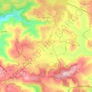
Name: Giv'at Ze'ev topographic map, elevation, terrain.
Location: Giv'at Ze'ev, Area C, Judea and Samaria, Palestinian Territory (31.82498 35.13554 31.87012 35.19174)
Average elevation: 751 m
Minimum elevation: 544 m
Maximum elevation: 887 m
Make a donation
Gear up for your next adventure:
As an Amazon Associate, this site earns from qualifying purchases at no extra cost to you.
Other topographic maps
Click on a map to view its topography, its elevation and its terrain.
Make a donation
Gear up for your next adventure:
As an Amazon Associate, this site earns from qualifying purchases at no extra cost to you.
Nabi Daniel
Palestinian Territory > Judea and Samaria > Area C > Beitar Ilit > Sde Boaz
Average elevation: 885 m
Make a donation
Gear up for your next adventure:
As an Amazon Associate, this site earns from qualifying purchases at no extra cost to you.
Talmon
Palestinian Territory > Judea and Samaria > Area C
Located at an elevation of nearly 600 metres and 18 km east of Modiin, it is organised as a community settlement and falls under the jurisdiction of Mateh Binyamin Regional Council. In 2022, it had a population of 5,379.
Average elevation: 522 m
Make a donation
Gear up for your next adventure:
As an Amazon Associate, this site earns from qualifying purchases at no extra cost to you.
Khallet Afana
Palestinian Territory > Judea and Samaria > Area C > Beitar Ilit
Average elevation: 909 m
Make a donation
Gear up for your next adventure:
As an Amazon Associate, this site earns from qualifying purchases at no extra cost to you.
Make a donation
Gear up for your next adventure:
As an Amazon Associate, this site earns from qualifying purchases at no extra cost to you.
Homesh
Palestinian Territory > Judea and Samaria > Area C > Shomron Regional Council
Average elevation: 452 m
Mevo Dotan
Palestinian Territory > Judea and Samaria > Area C > Shomron Regional Council
Average elevation: 264 m
Make a donation
Gear up for your next adventure:
As an Amazon Associate, this site earns from qualifying purchases at no extra cost to you.
Make a donation
Gear up for your next adventure:
As an Amazon Associate, this site earns from qualifying purchases at no extra cost to you.
Make a donation
Gear up for your next adventure:
As an Amazon Associate, this site earns from qualifying purchases at no extra cost to you.
Make a donation
Gear up for your next adventure:
As an Amazon Associate, this site earns from qualifying purchases at no extra cost to you.
Make a donation
Gear up for your next adventure:
As an Amazon Associate, this site earns from qualifying purchases at no extra cost to you.
Rotem
Palestinian Territory > Judea and Samaria > Area C > Arvot Hayarden Regional Council
Average elevation: -120 m
Make a donation
Gear up for your next adventure:
As an Amazon Associate, this site earns from qualifying purchases at no extra cost to you.