
Make a donation
Gear up for your next adventure:
As an Amazon Associate, this site earns from qualifying purchases at no extra cost to you.
Bastar topographic map
Click on the map to display elevation.
Make a donation
Gear up for your next adventure:
As an Amazon Associate, this site earns from qualifying purchases at no extra cost to you.
About this map
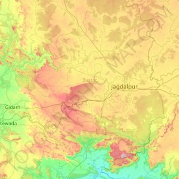
Name: Bastar topographic map, elevation, terrain.
Location: Bastar, Chhattisgarh, India (18.59490 81.34576 19.54131 82.24674)
Average elevation: 541 m
Minimum elevation: 213 m
Maximum elevation: 1,180 m
Make a donation
Gear up for your next adventure:
As an Amazon Associate, this site earns from qualifying purchases at no extra cost to you.
Other topographic maps
Click on a map to view its topography, its elevation and its terrain.
Make a donation
Gear up for your next adventure:
As an Amazon Associate, this site earns from qualifying purchases at no extra cost to you.
Sukma
India > Chhattisgarh > Sukma Tahsil
It is located at 18°24′0″N 81°40′0″E / 18.40000°N 81.66667°E / 18.40000; 81.66667 at an elevation of 210 m above MSL.
Average elevation: 219 m
Make a donation
Gear up for your next adventure:
As an Amazon Associate, this site earns from qualifying purchases at no extra cost to you.
Mahasamund
India > Chhattisgarh > Mahasamund Tahsil
Mahasamund is located at 21°06′N 82°06′E / 21.1°N 82.1°E / 21.1; 82.1. It has an average elevation of 318 metres (1043 feet). Mahasamund is 56 kilometres south-east of Raipur on the junction of National Highway 6 and National Highway 217 close to the Mahanadi River. Mahasamund city is an…
Average elevation: 291 m
Kirandul
India > Chhattisgarh > Kuakonda Tahsil
The Kothavalasa–Kirandul line of East Coast Railway from Kirandul to Visakhapatnam via Koraput is laid through the Eastern Ghats. Up to Araku station, it has many tunnels. Also it pass through the highest elevation Broad gauge station in the Eastern ghats, Semiliguda, just before the Borra caves. Kirandul -…
Average elevation: 742 m
Make a donation
Gear up for your next adventure:
As an Amazon Associate, this site earns from qualifying purchases at no extra cost to you.
Pendra
India > Chhattisgarh > Pendra Tahsil
Pendra has an average elevation of 617 metres (2,024 ft).
Average elevation: 594 m
Make a donation
Gear up for your next adventure:
As an Amazon Associate, this site earns from qualifying purchases at no extra cost to you.