
Make a donation
Gear up for your next adventure:
As an Amazon Associate, this site earns from qualifying purchases at no extra cost to you.
São Joaquim topographic map
Click on the map to display elevation.
Make a donation
Gear up for your next adventure:
As an Amazon Associate, this site earns from qualifying purchases at no extra cost to you.
São Joaquim
São Joaquim is a municipality in the state of Santa Catarina, situated in southern Brazil. It is located at latitude 28° 17' 38" south and longitude 49° 55' 54" west, with an altitude of 1,360 meters (4,460 ft). Its population in 2020 was 27,139 inhabitants. Located in the Planalto Serrano, it lies 136 km (85 miles) from Tubarão, 81 km (50 miles) from Lages and 227 km (141 miles) from Florianópolis. The town is home to a variety of ethnic groups, including Italian, German, Portuguese, Japanese and Afro-Brazilians. There are also many people from other states in Brazil, especially from Rio Grande do Sul.
Make a donation
Gear up for your next adventure:
As an Amazon Associate, this site earns from qualifying purchases at no extra cost to you.
About this map
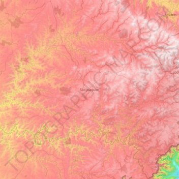
Name: São Joaquim topographic map, elevation, terrain.
Average elevation: 1,187 m
Minimum elevation: 133 m
Maximum elevation: 1,762 m
Make a donation
Gear up for your next adventure:
As an Amazon Associate, this site earns from qualifying purchases at no extra cost to you.
Other topographic maps
Click on a map to view its topography, its elevation and its terrain.
Make a donation
Gear up for your next adventure:
As an Amazon Associate, this site earns from qualifying purchases at no extra cost to you.