Geolocate

Viola topographic map

Click on the map to display elevation.

About this map

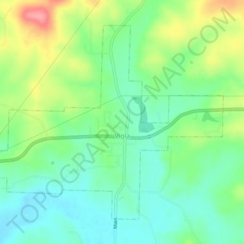
Name: Viola topographic map, elevation, terrain.

Location: Viola, Fulton County, Arkansas, 72583, United States (36.38566 -92.00614 36.41137 -91.96602)

Average elevation: 268 m

Minimum elevation: 234 m

Maximum elevation: 332 m

Other topographic maps

Click on a map to view its topography, its elevation and its terrain.

Elizabeth

United States > Arkansas > Fulton County

Average elevation: 233 m

Gear up for your next adventure:

🧣Evaporative Cooling Towel - Beat the heat during intense summer climbs
🧊Portable Cooler - Keep food and drinks cold during outdoor adventures
🧭GPS Outdoor Watch - Smart watch for navigation and fitness tracking in nature
🥾Durable Hiking Shoes - Long-lasting shoes for frequent hiking
🥫Freeze-Dried Meals - Lightweight, high-calorie nutrition for multi-day treks

As an Amazon Associate, this site earns from qualifying purchases at no extra cost to you.