Geolocate

Gilbert topographic map

Click on the map to display elevation.

About this map

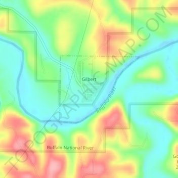
Name: Gilbert topographic map, elevation, terrain.

Location: Gilbert, Searcy County, Arkansas, 72636, United States (35.98466 -92.72184 35.99483 -92.70680)

Average elevation: 216 m

Minimum elevation: 166 m

Maximum elevation: 289 m

Other topographic maps

Click on a map to view its topography, its elevation and its terrain.

Harriet

United States > Arkansas > Searcy County

Average elevation: 294 m

Gear up for your next adventure:

🌡️Emergency Mylar Blankets - Compact thermal protection for unexpected nights outdoors
🧥Insulated Jacket - Keep warm in cold outdoor conditions
Family Camping Tent - Spacious tent suitable for family camping trips
🥽Outdoor Goggles - Protective eyewear for outdoor activities
🧥Softshell Hiking Jacket - The perfect balance of wind protection and breathability

As an Amazon Associate, this site earns from qualifying purchases at no extra cost to you.