Geolocate

Zweisimmen topographic map

Click on the map to display elevation.

About this map

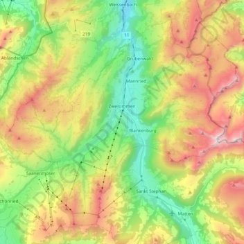
Name: Zweisimmen topographic map, elevation, terrain.

Location: Zweisimmen, Obersimmental-Saanen administrative district, Oberland administrative region, Bern, 3770, Switzerland (46.49068 7.27629 46.59893 7.46205)

Average elevation: 1,495 m

Minimum elevation: 834 m

Maximum elevation: 2,433 m

Other topographic maps

Click on a map to view its topography, its elevation and its terrain.

Gear up for your next adventure:

🥽Outdoor Goggles - Protective eyewear for outdoor activities
🧥Packable Rain Jacket - Breathable waterproof layer for unpredictable weather
🦶Hiking Shoe Insoles - Added support for high arches and long days on feet
🧢Hiking Sun Hat - Wide-brimmed protection for exposed mountain ridges
🔨Vehicle Emergency Tool - Safety tool for remote road trips to trailheads

As an Amazon Associate, this site earns from qualifying purchases at no extra cost to you.