Geolocate

Tubigan topographic map

Click on the map to display elevation.

About this map

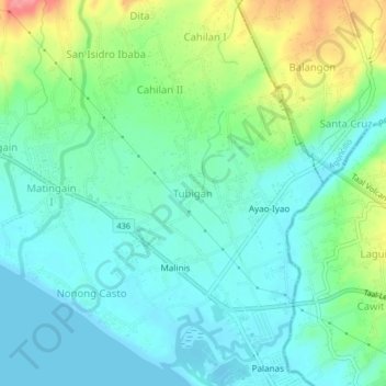
Name: Tubigan topographic map, elevation, terrain.

Location: Tubigan, Lemery, Batangas, Calabarzon, 4209, Philippines (13.89014 120.88184 13.93014 120.92184)

Average elevation: 29 m

Minimum elevation: 0 m

Maximum elevation: 108 m

Other topographic maps

Click on a map to view its topography, its elevation and its terrain.

Pansipit River

Philippines > Batangas > Lemery > Tubigan

Average elevation: 23 m

Pansipit River

Philippines > Batangas > Lemery > Tubigan

Average elevation: 23 m

Gear up for your next adventure:

🧥Softshell Jacket - Windproof and breathable jacket for hiking
🏕️Camping Hammock - Integrated protection for sleeping between trees
📷Outdoor Action Camera - Capture high-elevation views and rugged adventures
🧢Sun Hat - Wide-brim hat for sun protection
🪑Insulated Seat Pad - Protect your seat from cold rocks and wet logs

As an Amazon Associate, this site earns from qualifying purchases at no extra cost to you.