Geolocate

Wulfert topographic map

Click on the map to display elevation.

About this map

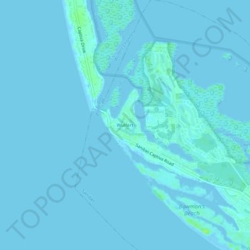
Name: Wulfert topographic map, elevation, terrain.

Location: Wulfert, Sanibel, Lee County, Florida, 33926, United States (26.46036 -82.19787 26.50036 -82.15787)

Average elevation: 1 m

Minimum elevation: -2 m

Maximum elevation: 11 m

Other topographic maps

Click on a map to view its topography, its elevation and its terrain.

Gear up for your next adventure:

🛶Canoe Life Vest - Safety vest for water sports
🦶Anti-Blister Balm - Prevents friction and hotspots during long ascents
🧥Thermal Layer - Insulating layer for cold outdoor conditions
🧴Sunscreen SPF - Broad-spectrum sunscreen for outdoor activities
🔭Outdoor Binoculars - Lightweight binoculars for birdwatching and hiking

As an Amazon Associate, this site earns from qualifying purchases at no extra cost to you.