
Spuzzum topographic map
Click on the map to display elevation.
Spuzzum
In 1956–57, contracts were awarded for the replacement of Spuzzum Creek bridge and associated roadwork, lying west of and higher than the railway bridge. In 1957–58, this work was completed. Once the new Alexandra Bridge opened in 1962, the highway bypassed Spuzzum at a higher elevation and the second Alexandra Bridge became redundant.
About this map
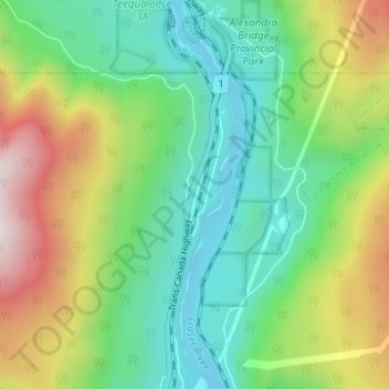
Name: Spuzzum topographic map, elevation, terrain.
Average elevation: 451 m
Minimum elevation: 51 m
Maximum elevation: 1,266 m
Fraser Valley Regional District trails, hiking, mountain biking, running and outdoor activities
Other topographic maps
Click on a map to view its topography, its elevation and its terrain.
Falls Lake
Canada > British Columbia > Fraser Valley Regional District > Area B (South Fraser Canyon/Sunshine Valley)
Average elevation: 1,512 m
Serpentine Lake
Canada > British Columbia > Fraser Valley Regional District > Area B (South Fraser Canyon/Sunshine Valley)
Average elevation: 960 m
Hope Slide
Canada > British Columbia > Fraser Valley Regional District > Area B (South Fraser Canyon/Sunshine Valley)
Average elevation: 1,160 m