Geolocate

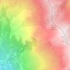
Les Teppes topographic map

Click on the map to display elevation.

About this map

Name: Les Teppes topographic map, elevation, terrain.

Location: Les Teppes, Saint-Michel-de-Maurienne, Saint-Jean-de-Maurienne, Savoie, Auvergne-Rhône-Alpes, France métropolitaine, 73140, France (45.21062 6.44542 45.25062 6.48542)

Average elevation: 1,057 m

Minimum elevation: 672 m

Maximum elevation: 1,981 m

Other topographic maps

Click on a map to view its topography, its elevation and its terrain.
Gear up for your next adventure:

💡Compact LED Flashlight - Powerful and portable flashlight for outdoor use
🛏️Camping Sleeping Mat - Comfortable mats for sleeping outdoors
🧥Softshell Hiking Jacket - The perfect balance of wind protection and breathability
💧Hydration Pack - Hands-free hydration system for long hikes
🔋Solar Power Bank - Keep your GPS and devices charged during long outdoor trips

As an Amazon Associate, this site earns from qualifying purchases at no extra cost to you.