
Refuge du Clot - Xavier Blanc topographic map
Interactive map
Click on the map to display elevation.
About this map
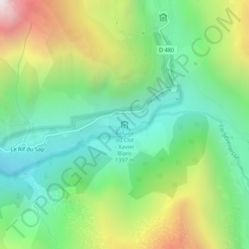
Name: Refuge du Clot - Xavier Blanc topographic map, elevation, terrain.
Average elevation: 1,797 m
Minimum elevation: 1,266 m
Maximum elevation: 2,803 m
Other topographic maps
Click on a map to view its topography, its elevation and its terrain.
Refuge de Chabournéou
France > Provence-Alpes-Côte d'Azur > Hautes-Alpes > La Chapelle-en-Valgaudémar > Le Rif du Sap
Refuge de Chabournéou, D 480, Le Rif du Sap, La Chapelle-en-Valgaudémar, Gap, Hautes-Alpes, Provence-Alpes-Côte d'Azur, France métropolitaine, 05800, France
Average elevation: 2,297 m