Geolocate

Salem topographic map

Click on the map to display elevation.

About this map

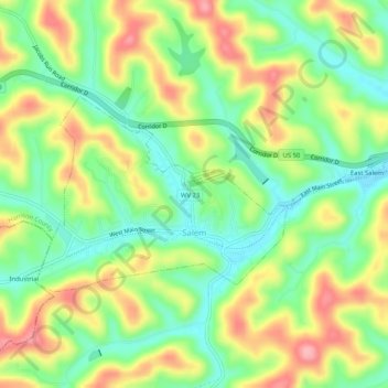
Name: Salem topographic map, elevation, terrain.

Location: Salem, Harrison County, West Virginia, 26375, United States (39.27678 -80.57987 39.29679 -80.52870)

Average elevation: 367 m

Minimum elevation: 313 m

Maximum elevation: 438 m

Gear up for your next adventure:

🧢Beanie Hat - Keep your head warm in cold weather
🥾Waterproof Hiking Shoes - Durable shoes for wet and rugged trails
🥾Mountaineering Boots - Supportive boots for climbing and high-altitude hiking
🔋Lithium AA Batteries - Long-lasting power that performs in extreme cold
🧢Hiking Hat - Sun-protective and breathable hats for long treks

As an Amazon Associate, this site earns from qualifying purchases at no extra cost to you.