
Make a donation
Gear up for your next adventure:
As an Amazon Associate, this site earns from qualifying purchases at no extra cost to you.
Ventron topographic map
Click on the map to display elevation.
Make a donation
Gear up for your next adventure:
As an Amazon Associate, this site earns from qualifying purchases at no extra cost to you.
About this map
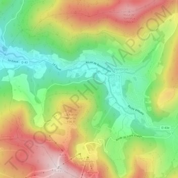
Name: Ventron topographic map, elevation, terrain.
Average elevation: 809 m
Minimum elevation: 565 m
Maximum elevation: 1,105 m
Make a donation
Gear up for your next adventure:
As an Amazon Associate, this site earns from qualifying purchases at no extra cost to you.
Other topographic maps
Click on a map to view its topography, its elevation and its terrain.
Le Grand Ventron
France > Grand Est > Vosges > Ventron
Le Grand Ventron est un sommet du massif des Vosges culminant à 1 204 m d'altitude. Il est partagé entre Ventron et Cornimont du côté lorrain et Kruth du côté alsacien. Plus au sud se trouve le Petit Ventron qui culmine à 1 155 mètres d'altitude.
Average elevation: 1,002 m
Make a donation
Gear up for your next adventure:
As an Amazon Associate, this site earns from qualifying purchases at no extra cost to you.