
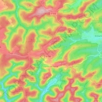
La Petite-Pierre topographic map
Interactive map
Click on the map to display elevation.
About this map
Name: La Petite-Pierre topographic map, elevation, terrain.
Average elevation: 314 m
Minimum elevation: 209 m
Maximum elevation: 413 m
L'origine de La Petite-Pierre est liée à un croisement de routes, l'une nord-sud, suivant l'axe du massif des Vosges, et l'autre reliant la plaine du Rhin, l'Alsace et le plateau lorrain. Cette position de col (340 m) se situe à une altitude moindre que le col le plus proche, le col de Saverne (410 m). Anciennement, cette différence avait une importance majeure pour les six mois d'hiver. Ceci se matérialise aujourd'hui par les voies départementales suivantes. la RD 7 venant de Bouxwiller et Weiterswiller (Ingwiller et Strasbourg) et la RD 9 vers Petersbach et Drulingen (Sarre-Union et l'autoroute A4), la liaison nord-sud étant assurée par la RD 135 depuis Zittersheim et Wingen-sur-Moder (Bitche), et la RD 178 venant du sud, côté Graufthal (Eschbourg), Oberhof, Dossenheim-sur-Zinsel (Phalsbourg et Saverne).
Other topographic maps
Click on a map to view its topography, its elevation and its terrain.
Lichtenberg
Lichtenberg, Saverne, Bas-Rhin, Grand Est, France métropolitaine, 67340, France
Average elevation: 279 m
Meistratzheim
Meistratzheim, Sélestat-Erstein, Bas-Rhin, Grand Est, France métropolitaine, 67210, France
Average elevation: 158 m
Strasbourg
Strasbourg, Bas-Rhin, Grand Est, France métropolitaine, France
Average elevation: 144 m
Stre.
France > Grand Est > Bas-Rhin > Oberlauterbach
Stre., Oberlauterbach, Haguenau-Wissembourg, Bas-Rhin, Grand Est, France métropolitaine, 67160, France
Average elevation: 171 m
Orschwiller
Orschwiller, Sélestat-Erstein, Bas-Rhin, Grand Est, France métropolitaine, 67600, France
Average elevation: 271 m
Engenthal
France > Grand Est > Bas-Rhin > Wangenbourg-Engenthal
Engenthal, Wangenbourg-Engenthal, Molsheim, Bas-Rhin, Grand Est, France métropolitaine, 67710, France
Average elevation: 530 m
Dorlisheim
Dorlisheim, Molsheim, Bas-Rhin, Grand Est, France métropolitaine, 67120, France
Average elevation: 205 m
Col du Donon
France > Grand Est > Bas-Rhin > Grandfontaine
Col du Donon, Haut Donon, Grandfontaine, Molsheim, Bas-Rhin, Grand Est, France métropolitaine, 67130, France
Average elevation: 694 m
Obersteinbach
Obersteinbach, Haguenau-Wissembourg, Bas-Rhin, Grand Est, France métropolitaine, 67510, France
Average elevation: 322 m
La Rothlach
France > Grand Est > Bas-Rhin > Le Hohwald
La Rothlach, Le Hohwald, Sélestat-Erstein, Bas-Rhin, Grand Est, France métropolitaine, 67140, France
Average elevation: 870 m
Bouxwiller
France > Grand Est > Bas-Rhin > Bouxwiller
Bouxwiller, Saverne, Bas-Rhin, Grand Est, France métropolitaine, 67330, France
Average elevation: 223 m
Le Hohwald
France > Grand Est > Bas-Rhin > Le Hohwald
Le Hohwald, Sélestat-Erstein, Bas-Rhin, Grand Est, France métropolitaine, 67140, France
Average elevation: 730 m
Mittelhausbergen
France > Grand Est > Bas-Rhin > Mittelhausbergen
Mittelhausbergen, Strasbourg, Bas-Rhin, Grand Est, France métropolitaine, 67206, France
Average elevation: 158 m
Mackenheim
France > Grand Est > Bas-Rhin > Mackenheim
Mackenheim, Sélestat-Erstein, Bas-Rhin, Grand Est, France métropolitaine, 67390, France
Average elevation: 174 m
Muttersholtz
France > Grand Est > Bas-Rhin > Muttersholtz
Muttersholtz, Sélestat-Erstein, Bas-Rhin, Grand Est, France métropolitaine, 67600, France
Average elevation: 167 m
Freudeneck
France > Grand Est > Bas-Rhin > Wangenbourg-Engenthal
Freudeneck, Wangenbourg-Engenthal, Molsheim, Bas-Rhin, Grand Est, France métropolitaine, 67710, France
Average elevation: 415 m
Schœnbourg
France > Grand Est > Bas-Rhin > Schœnbourg
Schœnbourg, Saverne, Bas-Rhin, Grand Est, France métropolitaine, 67320, France
Average elevation: 303 m
Breitenbach
Breitenbach, Sélestat-Erstein, Bas-Rhin, Grand Est, France métropolitaine, 67220, France
Average elevation: 608 m
Saint-Pierre
Saint-Pierre, Sélestat-Erstein, Bas-Rhin, Grand Est, France métropolitaine, 67140, France
Average elevation: 184 m
Preuschdorf
Preuschdorf, Haguenau-Wissembourg, Bas-Rhin, Grand Est, France métropolitaine, 67250, France
Average elevation: 234 m
La Walck
France > Grand Est > Bas-Rhin > Val-de-Moder
La Walck, Val-de-Moder, Haguenau-Wissembourg, Bas-Rhin, Grand Est, France métropolitaine, 67350, France
Average elevation: 189 m
Grandfontaine
Grandfontaine, Molsheim, Bas-Rhin, Grand Est, France métropolitaine, 67130, France
Average elevation: 610 m
Natzwiller
Natzwiller, Molsheim, Bas-Rhin, Grand Est, France métropolitaine, 67130, France
Average elevation: 705 m
Lauterbourg
Lauterbourg, Haguenau-Wissembourg, Bas-Rhin, Grand Est, France métropolitaine, 67630, France
Average elevation: 118 m