
Make a donation
Gear up for your next adventure:
As an Amazon Associate, this site earns from qualifying purchases at no extra cost to you.
Veensgarth topographic map
Click on the map to display elevation.
Make a donation
Gear up for your next adventure:
As an Amazon Associate, this site earns from qualifying purchases at no extra cost to you.
About this map
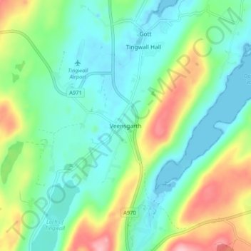
Name: Veensgarth topographic map, elevation, terrain.
Average elevation: 44 m
Minimum elevation: -7 m
Maximum elevation: 150 m
Make a donation
Gear up for your next adventure:
As an Amazon Associate, this site earns from qualifying purchases at no extra cost to you.
Other topographic maps
Click on a map to view its topography, its elevation and its terrain.
Make a donation
Gear up for your next adventure:
As an Amazon Associate, this site earns from qualifying purchases at no extra cost to you.
Lerwick
Vereinigtes Königreich > Schottland > Shetland
Am letzten Dienstag im Januar findet alljährlich das Up Helly Aa als Höhepunkt der Brauchtumspflege statt.
Average elevation: 34 m