
Make a donation
Gear up for your next adventure:
As an Amazon Associate, this site earns from qualifying purchases at no extra cost to you.
Ike Butte topographic map
Click on the map to display elevation.
Make a donation
Gear up for your next adventure:
As an Amazon Associate, this site earns from qualifying purchases at no extra cost to you.
About this map
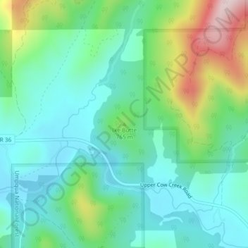
Name: Ike Butte topographic map, elevation, terrain.
Location: Ike Butte, Douglas County, Oregon, United States (42.83146 -123.07455 42.83156 -123.07445)
Average elevation: 699 m
Minimum elevation: 589 m
Maximum elevation: 993 m
Make a donation
Gear up for your next adventure:
As an Amazon Associate, this site earns from qualifying purchases at no extra cost to you.
Other topographic maps
Click on a map to view its topography, its elevation and its terrain.
Elkton
United States > Oregon > Douglas County
According to the United States Census Bureau, the city has a total area of 0.26 square miles (0.67 km2), of which, 0.23 square miles (0.60 km2) is land and 0.03 square miles (0.08 km2) is water. The elevation is 141 feet (43 m).
Average elevation: 95 m
Make a donation
Gear up for your next adventure:
As an Amazon Associate, this site earns from qualifying purchases at no extra cost to you.