Geolocate

Sector 23 topographic map

Click on the map to display elevation.

About this map

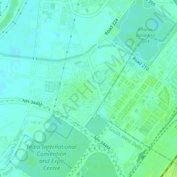
Name: Sector 23 topographic map, elevation, terrain.

Location: Sector 23, Dwarka, South West Delhi, Delhi, India (28.55466 77.03894 28.57034 77.05966)

Average elevation: 214 m

Minimum elevation: 209 m

Maximum elevation: 221 m

Other topographic maps

Click on a map to view its topography, its elevation and its terrain.

Tajpur Pahadi

India > Delhi

Average elevation: 209 m

Rangpuri

India > Delhi

Average elevation: 244 m

Sunder Nursery

India > Delhi

Average elevation: 209 m

Sanjay Lake Park

India > Delhi

Average elevation: 205 m

District Park Sarita Vihar

India > Delhi

Average elevation: 211 m

Chattarpur

India > Delhi

Average elevation: 261 m

Coronation Park

India > Delhi

Average elevation: 209 m

Coronation Park

India > Delhi

Average elevation: 209 m

Aya Nagar

India > Delhi

Average elevation: 272 m

Sunder Nursery

India > Delhi

Average elevation: 209 m

Aya Nagar

India > Delhi

Average elevation: 272 m

Coronation Park

India > Delhi

Average elevation: 209 m

Gear up for your next adventure:

🦟Insect Repellent - Keep mosquitoes and black flies away in wooded areas
Backpacking Tent - Lightweight tent for long-distance hiking trips
🥾Trail Hiking Boots - Supportive boots for rough trails
🔭Compact Binoculars - Lightweight optics for scouting trails and wildlife
🧦Hiking Liner Socks - Thin base layer to prevent friction and blisters

As an Amazon Associate, this site earns from qualifying purchases at no extra cost to you.