Geolocate

Jardín topographic map

Click on the map to display elevation.

About this map

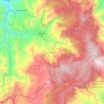
Name: Jardín topographic map, elevation, terrain.

Location: Jardín, Suroeste, Antioquia, 056050, Colombia (5.48039 -75.90587 5.65474 -75.73071)

Average elevation: 2,353 m

Minimum elevation: 1,259 m

Maximum elevation: 3,251 m

Gear up for your next adventure:

Family Camping Tent - Spacious tent suitable for family camping trips
🎒Fully Waterproof Backpack - Total protection for photography gear and electronics
💧Reusable Water Bottle - Durable water bottles for hydration on trails
🥾Trail Hiking Shoes - Durable shoes designed for rugged trails
🧥Waterproof Jacket - Lightweight rain jackets for hiking and outdoor activities

As an Amazon Associate, this site earns from qualifying purchases at no extra cost to you.