
Orange Springs topographic map
Click on the map to display elevation.
About this map
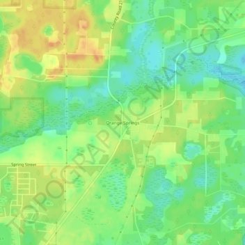
Name: Orange Springs topographic map, elevation, terrain.
Location: Orange Springs, Marion County, Florida, 32182, United States (29.48608 -81.96537 29.52608 -81.92537)
Average elevation: 21 m
Minimum elevation: 4 m
Maximum elevation: 38 m
Other topographic maps
Click on a map to view its topography, its elevation and its terrain.
Ocala
United States > Florida > Marion County
Ocala features a varied terrain of rolling hills, gently undulating plains, and rich limestone formations typical of north-central Florida. The area rests at an elevation that generally ranges from around 50 to 150 feet above sea level, with pockets of higher ground providing scenic overlooks and natural…
Average elevation: 28 m