
محافظة البرك topographic map
Interactive map
Click on the map to display elevation.
About this map
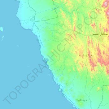
Name: محافظة البرك topographic map, elevation, terrain.
Location: محافظة البرك, Asir, Arabie saoudite (18.05784 40.72183 18.62279 41.81749)
Average elevation: 186 m
Minimum elevation: -1 m
Maximum elevation: 1,897 m
Other topographic maps
Click on a map to view its topography, its elevation and its terrain.
Um al-Baidh
Um al-Baidh, محافظة البرك, Asir, Arabie saoudite
Average elevation: 88 m
Al Hajir
Al Hajir, محافظة ظهران الجنوب, Asir, Arabie saoudite
Average elevation: 2,084 m