Geolocate

Puting Lupa topographic map

Click on the map to display elevation.

About this map

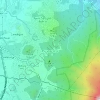
Name: Puting Lupa topographic map, elevation, terrain.

Location: Puting Lupa, Calamba, Laguna, Calabarzon, 4027, Philippines (14.13770 121.14975 14.16887 121.18920)

Average elevation: 239 m

Minimum elevation: 25 m

Maximum elevation: 983 m

Other topographic maps

Click on a map to view its topography, its elevation and its terrain.

La Mesa

Philippines > Laguna > Calamba

Average elevation: 240 m

88 Spa & Resort

Philippines > Laguna > Calamba

Average elevation: 83 m

San Juan River

Philippines > Laguna > Calamba

Average elevation: 9 m

Gear up for your next adventure:

🏕️Camping Hammock - Integrated protection for sleeping between trees
🥾Hiking Boots - Sturdy boots providing ankle support and traction on rugged trails
🔦LED Headtorch - Bright and durable light for night activities
🧰Survival Kit - Essential gear for emergencies in the wilderness
🦶Anti-Blister Balm - Prevents friction and hotspots during long ascents

As an Amazon Associate, this site earns from qualifying purchases at no extra cost to you.