
Catu topographic map
Click on the map to display elevation.
Catu
Catu is a prosperous city, with a prominent petroleum and commercial sector, both of which are equally well developed. It is known for its irregular topography and is located on the BR-110 between Salvador and Alagoinhas, approximately 78 km from the former and 32 km from the latter. It is part of Salvador's Metropolitan Region.
About this map
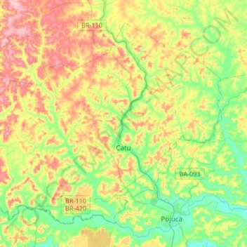
Name: Catu topographic map, elevation, terrain.
Average elevation: 125 m
Minimum elevation: 34 m
Maximum elevation: 246 m
Other topographic maps
Click on a map to view its topography, its elevation and its terrain.
Praia do Forte
Brazil > Bahia > Região Metropolitana de Salvador > Mata de São João
Average elevation: 5 m
Chapada Diamantina
The Chapada Diamantina lies at the center of Bahia State and forms the northern part of the Espinhaço Mountain Range. The region is approximately 38,000 km2 (15,000 sq mi) in area and encompasses 58 municipalities. Technically, this region is considered a part of the caatinga biome, and contains some of its…
Average elevation: 1,390 m
Campos
Brazil > Bahia > Região Administrativa Integrada de Desenvolvimento do Polo Petrolina e Juazeiro > Juazeiro
Average elevation: 387 m
Chapada Diamantina
The Chapada Diamantina lies at the center of Bahia State and forms the northern part of the Espinhaço Mountain Range. The region is approximately 38,000 km2 (15,000 sq mi) in area and encompasses 58 municipalities. Technically, this region is considered a part of the caatinga biome, and contains some of its…
Average elevation: 1,390 m
Costa do Sauípe
Brazil > Bahia > Região Metropolitana de Salvador > Mata de São João
Average elevation: 10 m
Serra do Cipó
Brazil > Bahia > Região Metropolitana de Feira de Santana > Ipecaetá
Average elevation: 254 m