
Deià topographic map
Interactive map
Click on the map to display elevation.
About this map
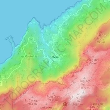
Name: Deià topographic map, elevation, terrain.
Location: Deià, Serra de Tramuntana, Балеарские острова, 07179, Испания (39.72490 2.61564 39.77236 2.67908)
Average elevation: 431 m
Minimum elevation: -1 m
Maximum elevation: 1,060 m
Other topographic maps
Click on a map to view its topography, its elevation and its terrain.
Valldemossa
Испания > Балеарские острова > Serra de Tramuntana
Valldemossa, Serra de Tramuntana, Балеарские острова, 07170, Испания
Average elevation: 360 m