Geolocate

Régina topographic map

Click on the map to display elevation.

About this map
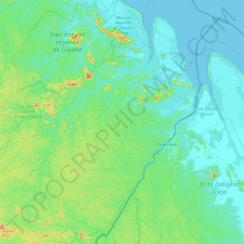
Name: Régina topographic map, elevation, terrain.

Location: Régina, Saint-Georges, French Guiana, France (3.18874 -53.23319 4.78907 -51.75012)

Average elevation: 63 m

Minimum elevation: -3 m

Maximum elevation: 654 m

Other topographic maps

Click on a map to view its topography, its elevation and its terrain.

Fedi

France > French Guiana > Apatou

Average elevation: 31 m

Saint Joseph Island

France > French Guiana > Cayenne

Average elevation: 1 m

Devil's Island

France > French Guiana > Cayenne

Average elevation: 1 m

Crique Paracou

France > French Guiana > Sinnamary

Average elevation: 5 m

Tampok

France > French Guiana

Average elevation: 154 m

Lawa

France > French Guiana > Maripasoula

Average elevation: 110 m

Montagne d'Argent

France > French Guiana > Ouanary

Average elevation: 9 m

Dobai

France > French Guiana > Grand-Santi

Average elevation: 39 m

Lawa

France > French Guiana > Maripasoula

Average elevation: 110 m

Gear up for your next adventure:

💡Compact LED Flashlight - Powerful and portable flashlight for outdoor use
⛺Family Camping Tent - Spacious tent suitable for family camping trips
🥾Trekking Poles - Adjustable trekking poles to reduce knee stress and improve stability
🧥Fleece Jacket - Warm and lightweight jacket for layering
🧣Merino Neck Gaiter - Protects against wind, sun, and cold at high altitudes

As an Amazon Associate, this site earns from qualifying purchases at no extra cost to you.