Geolocate

Napier topographic map

Click on the map to display elevation.

About this map

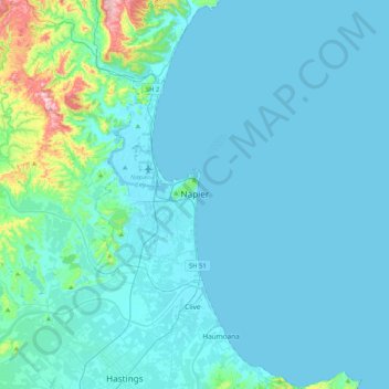
Name: Napier topographic map, elevation, terrain.

Location: Napier, Napier City, Hawke's Bay, 4001, New Zealand (-39.65021 176.75784 -39.33021 177.07784)

Average elevation: 33 m

Minimum elevation: -2 m

Maximum elevation: 370 m

Gear up for your next adventure:

🥘Camping Cookware Set - Compact nesting pots and pans for trail cooking
💧Reusable Water Bottle - Durable water bottles for hydration on trails
🧰Survival Kit - Essential gear for emergencies in the wilderness
🚑Survival Whistle - Signal for help across long distances in mountains
🕶️Polarized Sunglasses - Protect your eyes with durable polarized lenses

As an Amazon Associate, this site earns from qualifying purchases at no extra cost to you.