

Majorca topographic map
Click on the map to display elevation.
Majorca
Mallorca and the other Balearic Islands are geologically an extension of the fold mountains of the Betic Cordillera of Andalusia. They consist primarily of sediments deposited in the Tethys Sea during the Mesozoic era. These marine deposits have given rise to calcareous rocks which are often fossiliferous. The folding of the Betic Cordillera and Mallorcan ranges resulted from subduction of the African plate beneath the Eurasian plate with eventual collision. Tectonic movements led to different elevation and lowering zones in the late Tertiary period, which is why the connection to the mainland has been severed at the current sea level.
About this map
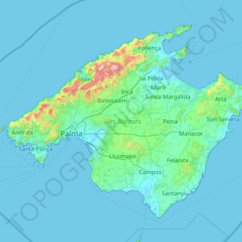
Name: Majorca topographic map, elevation, terrain.
Location: Majorca, Balearic Islands, Spain (39.26434 2.34473 39.96251 3.47875)
Average elevation: 61 m
Minimum elevation: -3 m
Maximum elevation: 1,368 m
Other topographic maps
Click on a map to view its topography, its elevation and its terrain.
Urbanització Cala Llonga
Spain > Balearic Islands > Ibiza > Santa Eulària des Riu
Average elevation: 39 m