Geolocate

Cumba topographic map

Click on the map to display elevation.

About this map

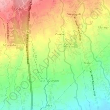
Name: Cumba topographic map, elevation, terrain.

Location: Cumba, Lipa, Batangas, Calabarzon, 4217, Philippines (13.87976 121.11663 13.91976 121.15663)

Average elevation: 267 m

Minimum elevation: 208 m

Maximum elevation: 331 m

Gear up for your next adventure:

👖Convertible Hiking Pants - Zip-off legs to adapt to changing weather conditions
🔥Camping Stove - Portable stoves to cook outdoors with ease
Camping Coffee Maker - Brew fresh coffee anywhere on the topographic map
🧢Sun Hat - Wide-brim hat for sun protection
🔦LED Headtorch - Bright and durable light for night activities

As an Amazon Associate, this site earns from qualifying purchases at no extra cost to you.