Geolocate

Manjuyod topographic map

Click on the map to display elevation.

About this map

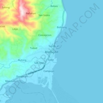
Name: Manjuyod topographic map, elevation, terrain.

Location: Manjuyod, Negros Oriental, Central Visayas, Philippines (9.63885 123.10881 9.71885 123.18881)

Average elevation: 72 m

Minimum elevation: 0 m

Maximum elevation: 630 m

Gear up for your next adventure:

🔨Vehicle Emergency Tool - Safety tool for remote road trips to trailheads
💧Reusable Water Bottle - Durable water bottles for hydration on trails
👟Trail Running Shoes - Agile footwear for fast-paced topographic exploration
📷Outdoor Action Camera - Capture high-elevation views and rugged adventures
🧳Compression Sacks - Maximize space in your backpack by shrinking gear

As an Amazon Associate, this site earns from qualifying purchases at no extra cost to you.