Geolocate

Buesaco topographic map

Click on the map to display elevation.

About this map

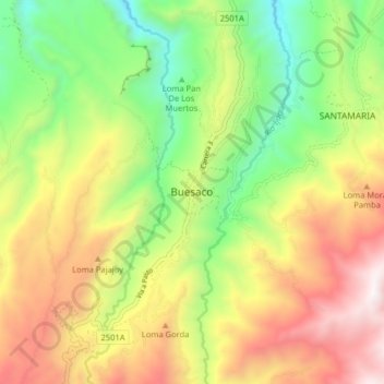
Name: Buesaco topographic map, elevation, terrain.

Location: Buesaco, Juanambú, Nariño, Colombia (1.34410 -77.19662 1.42410 -77.11662)

Average elevation: 1,965 m

Minimum elevation: 1,309 m

Maximum elevation: 2,767 m

Gear up for your next adventure:

🔦LED Flashlight - Powerful and long-lasting flashlight for camping and emergencies
🧢Hiking Sun Hat - Wide-brimmed protection for exposed mountain ridges
Camping Tent - Weather-resistant tents suitable for 2 to 6 people
Tent Footprint - Protect tent floor and increase durability
🔋Lithium AA Batteries - Long-lasting power that performs in extreme cold

As an Amazon Associate, this site earns from qualifying purchases at no extra cost to you.