Geolocate

Acacías topographic map

Click on the map to display elevation.

About this map

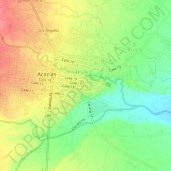
Name: Acacías topographic map, elevation, terrain.

Location: Acacías, Meta, 507001, Colombia (3.96611 -73.77830 4.00611 -73.73830)

Average elevation: 524 m

Minimum elevation: 484 m

Maximum elevation: 565 m

Gear up for your next adventure:

🧦Hiking Liner Socks - Thin base layer to prevent friction and blisters
💡LED Camping Lantern - Illuminate your campsite with long-lasting lanterns
🥾Lightweight Hiking Boots - Boots for comfort and mobility on long hikes
🧢Sun Hat - Wide-brim hat for sun protection
🧦Hiking Socks - Moisture-wicking and comfortable socks for long hikes

As an Amazon Associate, this site earns from qualifying purchases at no extra cost to you.