
Make a donation
Gear up for your next adventure:
As an Amazon Associate, this site earns from qualifying purchases at no extra cost to you.
Mont des Cats topographic map
Click on the map to display elevation.
Make a donation
Gear up for your next adventure:
As an Amazon Associate, this site earns from qualifying purchases at no extra cost to you.
Mont des Cats
Le mont des Cats (en néerlandais : Katsberg) est une hauteur située sur le territoire des communes de Berthen, Godewaersvelde et Méteren, en Flandre française, dans la région Hauts-de-France. Son altitude est de 164 m.
Make a donation
Gear up for your next adventure:
As an Amazon Associate, this site earns from qualifying purchases at no extra cost to you.
About this map
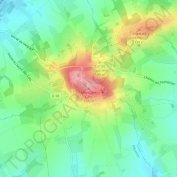
Name: Mont des Cats topographic map, elevation, terrain.
Average elevation: 86 m
Minimum elevation: 40 m
Maximum elevation: 167 m
Make a donation
Gear up for your next adventure:
As an Amazon Associate, this site earns from qualifying purchases at no extra cost to you.
Other topographic maps
Click on a map to view its topography, its elevation and its terrain.
Émetteur FM/TNT Dunkerque/Mont-des-Cats
France > Hauts-de-France > Nord > Berthen
Average elevation: 86 m