Geolocate

Taylor topographic map

Click on the map to display elevation.

About this map

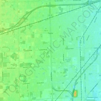
Name: Taylor topographic map, elevation, terrain.

Location: Taylor, Wayne County, Michigan, 48180, United States (42.18128 -83.30900 42.26989 -83.22814)

Average elevation: 188 m

Minimum elevation: 179 m

Maximum elevation: 204 m

Gear up for your next adventure:

🧤Rechargeable Heated Gloves - Extreme warmth for Canadian winter expeditions
🧥Fleece Jacket - Warm and lightweight jacket for layering
🔭Outdoor Binoculars - Lightweight binoculars for birdwatching and hiking
🧰Survival Kit - Essential gear for emergencies in the wilderness
🥾Hiking Gaiters - Protect legs and shoes from mud, snow, and debris

As an Amazon Associate, this site earns from qualifying purchases at no extra cost to you.