Geolocate

Albavilla topographic map

Click on the map to display elevation.

About this map

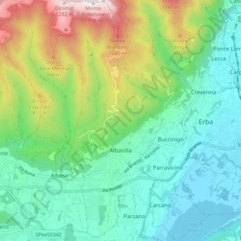
Name: Albavilla topographic map, elevation, terrain.

Location: Albavilla, Como, Lombardy, 22031, Italy (45.78208 9.16486 45.83768 9.21709)

Average elevation: 550 m

Minimum elevation: 254 m

Maximum elevation: 1,296 m

Gear up for your next adventure:

👟Sport Hiking Sandals - Breathable footwear for water crossings and camp rest
🥾Hiking Leggings - Comfortable leggings for outdoor activities
💡Solar Camping Lamp - Eco-friendly lighting for campsites
🔦LED Flashlight - Powerful and long-lasting flashlight for camping and emergencies
Camping Coffee Maker - Brew fresh coffee anywhere on the topographic map

As an Amazon Associate, this site earns from qualifying purchases at no extra cost to you.